
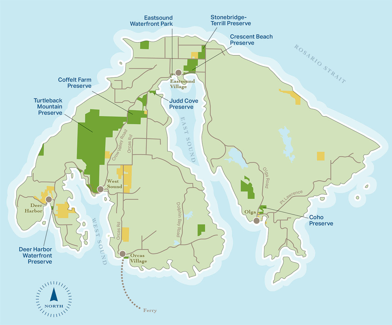
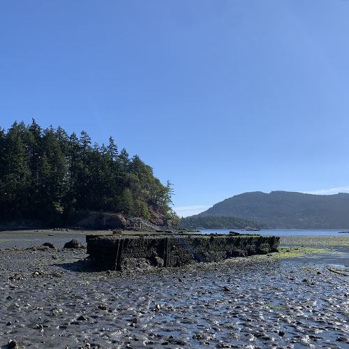
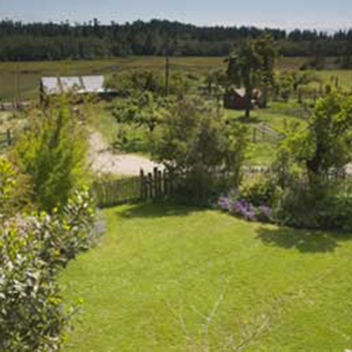
Orcas Island
Orcas Island has the highest mountain peaks in the county. Narrow, winding roads connect its hamlets and villages
Click pins to view land details.
OPEN TO THE PUBLIC
CLOSED TO PUBLIC ACCESS


Download Map (PDF) Here
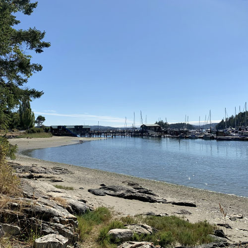
EASTSOUND WATERFRONT PARK
Located on the main entrance road to Eastsound Village, the Land Bank’s first acquisition in 1993 added .45 acres and 100 feet of shoreline to the existing county park. The popular Waterfront Park preserves views of the water from the village and allows public access to the shoreline and nearby publicly-owned Indian Island. In 2003, the Land Bank acquired an adjacent one-acre parcel and 356 feet of waterfront. An additional .45 acre property abutting the eastern boundary of the park was acquired later to further expand the size of the park and increase water frontage by another 100 feet.
OPEN TO THE PUBLIC
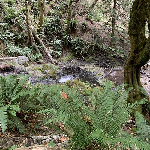
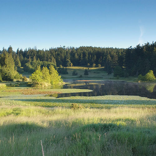
COHO PRESERVE
Coho Preserve is a small yet exceptional natural area which was acquired through a grant from the Salmon Recovery Funding Board. Surrounded by towering forest, this magical 24 acre preserve is home to multiple songbirds, raptors, salmon and trout. This rich variety of habitat along Cascade Creek can be relished while hiking the rustic trail loop through the preserve.
OPEN TO THE PUBLIC
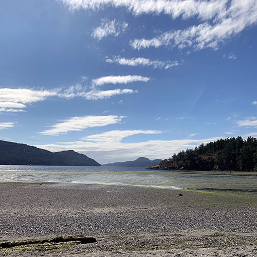
CRESCENT BEACH PRESERVE
Waterfront access on Orcas Island is a high priority for locals. Crescent Beach, with its outstanding scenic values, ecological resources, and potential for public access has been a top conservation priority for the Land Bank since the beginning of the program. An acquisition of 112 acres in 1998 included nearly 300 feet of no-bank beach waterfront and an extensive wetland system including a large pristine wetland adjacent to Crescent Beach. Another in 2000 added an additional 5 acres and 855 feet of waterfront. In 2002 and 2005, the preserve expanded further with the addition of 13.75 acres and 968 more feet of shoreline providing new options for enjoyment, access, walking trails, and parking. Crescent Beach Preserve is a gem for marine study and public enjoyment.
OPEN TO THE PUBLIC
DEER HARBOR WATERFRONT PRESERVE
These precious two acres with 650 feet of low-bank marine shoreline and associated tidelands are ideally located just north of the Deer Harbor hamlet. A walking path of mixed forest and an area of open meadow provides public access to the shoreline and views across the harbor to the Wasp Islands. A variety of birds utilize this land including bald eagles, osprey, kingfishers, and hummingbirds. The Land Bank’s restoration efforts here have improved important shoreline processes and habitat function to benefit forage fish that are essential to salmon.
OPEN TO THE PUBLIC
STONEBRIDGE-TERRILL PRESERVE
Stonebridge-Terrill Preserve protects 59 acres of meadow, wetlands, and forest. Used historically for agriculture, a portion of this land still yields hay for island livestock. The preserve provides varied habitat for wildlife, retains stormwater, and helps recharge aquifers. A short trail into a forested wetland and wildlife observation area is open year-round. The mowed portion of the preserve is open to the public following mowing in late summer with walk-in access from the adjacent county roads. A portion of the field is also used occasionally by the Orcas Radio Control Aircraft Society.
OPEN TO THE PUBLIC
JUDD COVE PRESERVE
The Judd Cove Preserve is an exquisite jewel along the western shore of East Sound. Comprised of three parcels acquired by the Land Bank from 2000 - 2008, the 11-acre natural area encompasses a rich variety of habitats, including mature mixed forest, 355 feet of marine shoreline, freshwater wetlands, and extensive tidelands. The site is also the location of a partially restored 1880’s lime kiln and quarry which help tell the story of the lime industry in the San Juans. The peaceful and picturesque setting of this sanctuary offers pedestrian shoreline access and special opportunities for wildlife watching.
OPEN TO THE PUBLIC
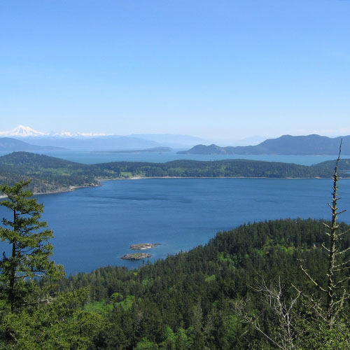
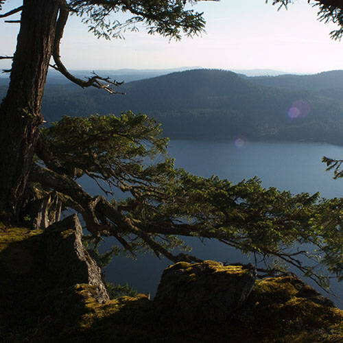
TURTLEBACK MOUNTAIN PRESERVE
Turtleback Mountain Preserve is one of the most familiar and beloved landscapes in the San Juan Islands. Treasured by islanders for its dark, undeveloped ridge line, it is a refuge for wildlife and a haven for those who wander the trails through a mosaic of forests, wetlands and open meadows. Turtleback Mountain is one of the largest undeveloped places in the county. Sheltering a variety of special habitats and species, the preserve is ecologically significant as well as beautiful. Grasslands and Garry oak woodlands cover the mountain’s dry southern slopes while conifer forest blankets the remainder. Pocket wetlands scattered about the property provide crucial habitat for wildlife and moisture-loving plants. Seasonal drainage from the mountain nourishes the fertile wetlands of Crow Valley and the rich marine habitats of West Sound. Towering over Crow Valley and West Sound, Turtleback Mountain is visible from many vantage points throughout the county and beyond. Turtleback is a recreational resource. Its high meadows and rocky ledges provide unparalleled views of the San Juan and Canadian Gulf Islands. There are a variety of trails for hiking, bird watching, and wildlife viewing. All trails are open for pedestrian use year-round. Within the multi-use trail area, horses and bikes are allowed on an even/odd day rotation – bikes on even calendar days and horses on odd calendar days – via the north trailhead. A major conservation effort in 2006 with partners and citizens made Turtleback a reality, and more recently, our partnership with San Juan Preservation Trust expanded and connected public access from Turtlehead to Turtleback via what is known to the community as "Turtleneck."
OPEN TO THE PUBLIC
COFFELT FARM PRESERVE
To help ensure a future of local agriculture, the Land Bank purchased Coffelt Farm on Orcas Island. The 185 acres spans Crow Valley, encompassing an expanse of scenic open-space, habitat resources, and productive agricultural land. In 1995, Vern and Sidney Coffelt worked with the Land Bank to place a conservation easement on their farm to limit development and protect special features of the land. The easement was an important step, but it did not ensure that future landowners would continue to farm the property. After 60 years of working the land, and with a conviction that it must be made available to future generations of farmers, the Coffelts sold the bulk of the farm to the Land Bank in 2008. 10 acres remain privately owned under the conservation easement. The terms of the easement allow for one residential dwelling and protect farm fields and views.
OPEN TO THE PUBLIC
DIAMOND HILL PRESERVE
Diamond Hill rises to over 600 feet above the waters of Eastsound and Harney Channel. This diverse and secluded 45-acre preserve includes grassy meadows, a quiet wetland that supports breeding amphibians, and abundant wildlife. Most of the preserve was purchased from the Washington State Department of Natural Resources. Five acres were donated by a generous neighbor.
CLOSED TO PUBLIC ACCESS
ENTRANCE MOUNTAIN PRESERVE
These four parcels of special land located on Entrance Mountain are important scenic and natural areas. One 48-acre parcel is located on the ridge-top and west-facing side of the mountain. This is the north knob of the mountain. A second 32-acre parcel is on the eastern face of the mountain and can be seen from many locations on Mount Constitution. The third 10-acre parcel on its northern flanks can be spotted from Cascade Lake. In January 2008, an adjacent 36 acres was donated by the William Halpenny Estate. The Halpenny addition has rugged topography and is heavily forested. Of particular note is the prevalence of Sitka spruce and scattered areas of mature big leaf maple. At higher elevations, slide chutes and boulders are coated by lush moss, adding another element to the land’s many-textured features and providing an array of opportunities for wildlife.
CLOSED TO PUBLIC ACCESS
FOWLER'S POND PRESERVE
Fowler’s Pond is a beloved Orcas Island landmark. These 40.25 acres include gently sloping grassy meadows, woodlands, and two scenic ponds. Preserved together, these habitats provide a biologically-rich environment. Some of the wildlife residents include common snipes, coots, wood ducks, pacific chorus frogs, red-legged frogs, and rough skin newts. Guided by public opinion, access to this wildlife preserve is currently by permission only, yet Fowler’s Pond remains a favorite scenic vista from both Horseshoe Highway and Crow Valley Road. In 2006, the addition of an adjacent nine forested hilltop acres known as “Fowler’s Knob” expanded this preserve to what it is today.
CLOSED TO PUBLIC ACCESS
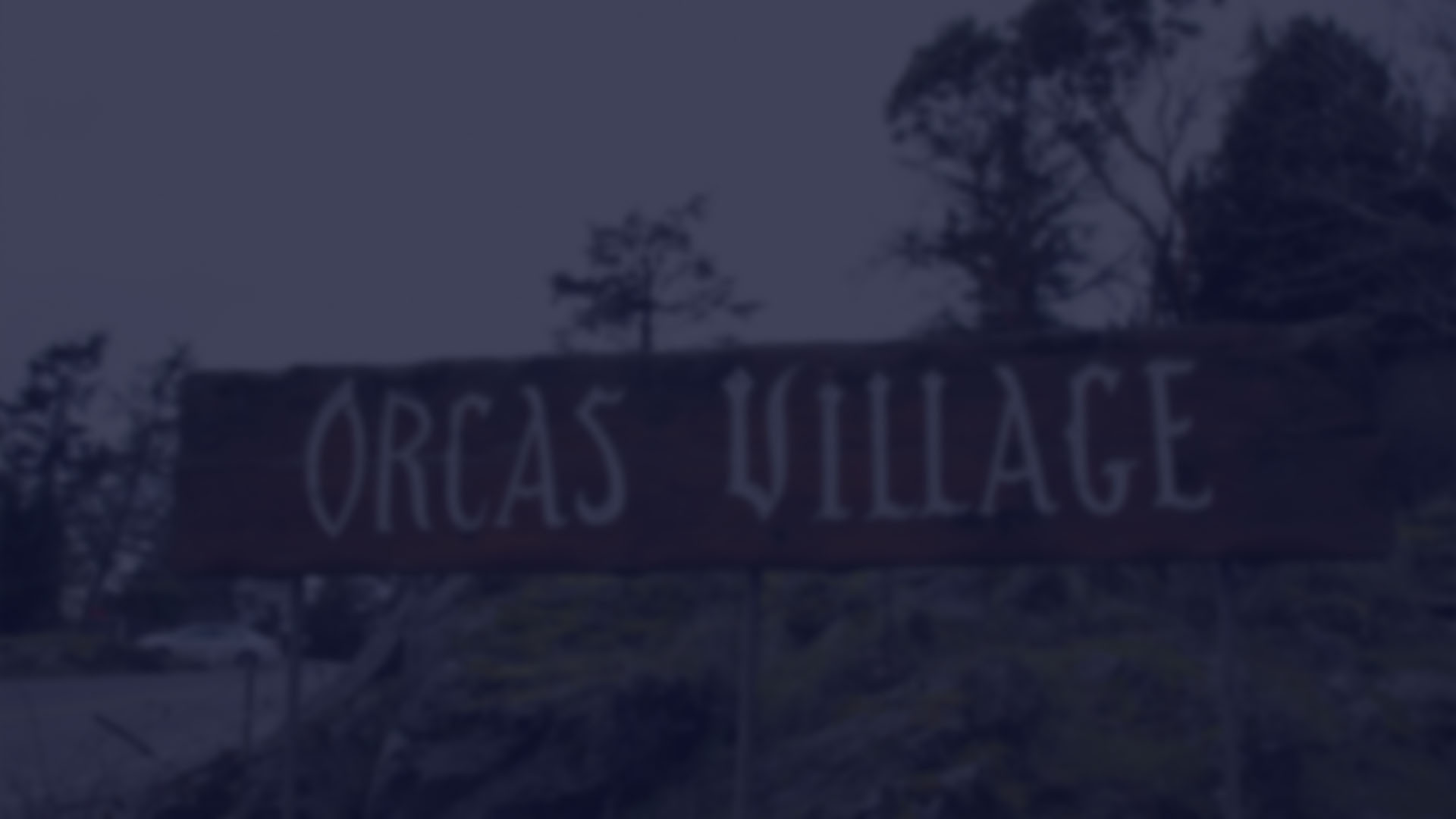
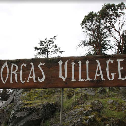
ORCAS VILLAGE TIDELANDS
Adjacent to the Orcas ferry landing, the Orcas Village tidelands contain important eelgrass beds and marine habitat. They were vulnerable to a highly-contested marina proposal. The Save Orcas Bay Alliance purchased the tidelands and donated fee title to the Land Bank. A conservation easement was gifted to the private nonprofit land conservation organization, The San Juan Preservation Trust, adding an additional layer of protection.
CLOSED TO PUBLIC ACCESS
PRESIDENT CHANNEL PRESERVE
An abundance of juvenile Chinook salmon making their way out to the open sea are supported by President Channel Preserve’s 2,500 feet of shoreline. This land also includes a historic lime kiln, bald eagle nesting, madrona woodland, and coastal prairie. The San Juan Preservation Trust and the Washington State Salmon Recovery Funding Board covered the entire cost of purchasing this preserve.
CLOSED TO PUBLIC ACCESS
Orcas Island
Orcas Island has the highest mountain peaks in the county. Narrow, winding roads connect its hamlets and villages.
Click pins to view land details.
OPEN TO THE PUBLIC
CLOSED TO PUBLIC ACCESS
Download Map (PDF) Here
EASTSOUND WATERFRONT PARK
Located on the main entrance road to Eastsound Village, the Land Bank’s first acquisition in 1993 added .45 acres and 100 feet of shoreline to the existing county park. The popular Waterfront Park preserves views of the water from the village and allows public access to the shoreline and nearby publicly-owned Indian Island. In 2003, the Land Bank acquired an adjacent one-acre parcel and 356 feet of waterfront. An additional .45 acre property abutting the eastern boundary of the park was acquired later to further expand the size of the park and increase water frontage by another 100 feet.
OPEN TO THE PUBLIC
COHO PRESERVE
Coho Preserve is a small yet exceptional natural area which was acquired through a grant from the Salmon Recovery Funding Board. Surrounded by towering forest, this magical 24 acre preserve is home to multiple songbirds, raptors, salmon and trout. This rich variety of habitat along Cascade Creek can be relished while hiking the rustic trail loop through the preserve.
OPEN TO THE PUBLIC
CRESCENT BEACH PRESERVE
Waterfront access on Orcas Island is a high priority for locals. Crescent Beach, with its outstanding scenic values, ecological resources, and potential for public access has been a top conservation priority for the Land Bank since the beginning of the program. An acquisition of 112 acres in 1998 included nearly 300 feet of no-bank beach waterfront and an extensive wetland system including a large pristine wetland adjacent to Crescent Beach. Another in 2000 added an additional 5 acres and 855 feet of waterfront. In 2002 and 2005, the preserve expanded further with the addition of 13.75 acres and 968 more feet of shoreline providing new options for enjoyment, access, walking trails, and parking. Crescent Beach Preserve is a gem for marine study and public enjoyment.
OPEN TO THE PUBLIC
DEER HARBOR WATERFRONT PRESERVE
These precious two acres with 650 feet of low-bank marine shoreline and associated tidelands are ideally located just north of the Deer Harbor hamlet. A walking path of mixed forest and an area of open meadow provides public access to the shoreline and views across the harbor to the Wasp Islands. A variety of birds utilize this land including bald eagles, osprey, kingfishers, and hummingbirds. The Land Bank’s restoration efforts here have improved important shoreline processes and habitat function to benefit forage fish that are essential to salmon.
OPEN TO THE PUBLIC
STONEBRIDGE-TERRILL PRESERVE
Stonebridge-Terrill Preserve protects 59 acres of meadow, wetlands, and forest. Used historically for agriculture, a portion of this land still yields hay for island livestock. The preserve provides varied habitat for wildlife, retains stormwater, and helps recharge aquifers. A short trail into a forested wetland and wildlife observation area is open year-round. The mowed portion of the preserve is open to the public following mowing in late summer with walk-in access from the adjacent county roads. A portion of the field is also used occasionally by the Orcas Radio Control Aircraft Society.
OPEN TO THE PUBLIC
JUDD COVE PRESERVE
The Judd Cove Preserve is an exquisite jewel along the western shore of East Sound. Comprised of three parcels acquired by the Land Bank from 2000 - 2008, the 11-acre natural area encompasses a rich variety of habitats, including mature mixed forest, 355 feet of marine shoreline, freshwater wetlands, and extensive tidelands. The site is also the location of a partially restored 1880’s lime kiln and quarry which help tell the story of the lime industry in the San Juans. The peaceful and picturesque setting of this sanctuary offers pedestrian shoreline access and special opportunities for wildlife watching.
OPEN TO THE PUBLIC
TURTLEBACK MOUNTAIN PRESERVE
Turtleback Mountain Preserve is one of the most familiar and beloved landscapes in the San Juan Islands. Treasured by islanders for its dark, undeveloped ridge line, it is a refuge for wildlife and a haven for those who wander the trails through a mosaic of forests, wetlands and open meadows. Turtleback Mountain is one of the largest undeveloped places in the county. Sheltering a variety of special habitats and species, the preserve is ecologically significant as well as beautiful. Grasslands and Garry oak woodlands cover the mountain’s dry southern slopes while conifer forest blankets the remainder. Pocket wetlands scattered about the property provide crucial habitat for wildlife and moisture-loving plants. Seasonal drainage from the mountain nourishes the fertile wetlands of Crow Valley and the rich marine habitats of West Sound. Towering over Crow Valley and West Sound, Turtleback Mountain is visible from many vantage points throughout the county and beyond. Turtleback is a recreational resource. Its high meadows and rocky ledges provide unparalleled views of the San Juan and Canadian Gulf Islands. There are a variety of trails for hiking, bird watching, and wildlife viewing. All trails are open for pedestrian use year-round. Within the multi-use trail area, horses and bikes are allowed on an even/odd day rotation – bikes on even calendar days and horses on odd calendar days – via the north trailhead. A major conservation effort in 2006 with partners and citizens made Turtleback a reality, and more recently, our partnership with San Juan Preservation Trust expanded and connected public access from Turtlehead to Turtleback via what is known to the community as "Turtleneck."
OPEN TO THE PUBLIC
COFFELT FARM PRESERVE
To help ensure a future of local agriculture, the Land Bank purchased Coffelt Farm on Orcas Island. The 185 acres spans Crow Valley, encompassing an expanse of scenic open-space, habitat resources, and productive agricultural land. In 1995, Vern and Sidney Coffelt worked with the Land Bank to place a conservation easement on their farm to limit development and protect special features of the land. The easement was an important step, but it did not ensure that future landowners would continue to farm the property. After 60 years of working the land, and with a conviction that it must be made available to future generations of farmers, the Coffelts sold the bulk of the farm to the Land Bank in 2008. 10 acres remain privately owned under the conservation easement. The terms of the easement allow for one residential dwelling and protect farm fields and views.
OPEN TO THE PUBLIC
DIAMOND HILL PRESERVE
Diamond Hill rises to over 600 feet above the waters of Eastsound and Harney Channel. This diverse and secluded 45-acre preserve includes grassy meadows, a quiet wetland that supports breeding amphibians, and abundant wildlife. Most of the preserve was purchased from the Washington State Department of Natural Resources. Five acres were donated by a generous neighbor.
CLOSED TO PUBLIC ACCESS
ENTRANCE MOUNTAIN PRESERVE
These four parcels of special land located on Entrance Mountain are important scenic and natural areas. One 48-acre parcel is located on the ridge-top and west-facing side of the mountain. This is the north knob of the mountain. A second 32-acre parcel is on the eastern face of the mountain and can be seen from many locations on Mount Constitution. The third 10-acre parcel on its northern flanks can be spotted from Cascade Lake. In January 2008, an adjacent 36 acres was donated by the William Halpenny Estate. The Halpenny addition has rugged topography and is heavily forested. Of particular note is the prevalence of Sitka spruce and scattered areas of mature big leaf maple. At higher elevations, slide chutes and boulders are coated by lush moss, adding another element to the land’s many-textured features and providing an array of opportunities for wildlife.
CLOSED TO PUBLIC ACCESS
FOWLER'S POND PRESERVE
Fowler’s Pond is a beloved Orcas Island landmark. These 40.25 acres include gently sloping grassy meadows, woodlands, and two scenic ponds. Preserved together, these habitats provide a biologically-rich environment. Some of the wildlife residents include common snipes, coots, wood ducks, pacific chorus frogs, red-legged frogs, and rough skin newts. Guided by public opinion, access to this wildlife preserve is currently by permission only, yet Fowler’s Pond remains a favorite scenic vista from both Horseshoe Highway and Crow Valley Road. In 2006, the addition of an adjacent nine forested hilltop acres known as “Fowler’s Knob” expanded this preserve to what it is today.
CLOSED TO PUBLIC ACCESS
ORCAS VILLAGE TIDELADNDS
Adjacent to the Orcas ferry landing, the Orcas Village tidelands contain important eelgrass beds and marine habitat. They were vulnerable to a highly-contested marina proposal. The Save Orcas Bay Alliance purchased the tidelands and donated fee title to the Land Bank. A conservation easement was gifted to the private nonprofit land conservation organization, The San Juan Preservation Trust, adding an additional layer of protection.
CLOSED TO PUBLIC ACCESS
PRESIDENT CHANNEL PRESERVE
An abundance of juvenile Chinook salmon making their way out to the open sea are supported by President Channel Preserve’s 2,500 feet of shoreline. This land also includes a historic lime kiln, bald eagle nesting, madrona woodland, and coastal prairie. The San Juan Preservation Trust and the Washington State Salmon Recovery Funding Board covered the entire cost of purchasing this preserve.
CLOSED TO PUBLIC ACCESS